Choosing the best navigator for iPhone.
Navigators for iPhone have flooded the appstore, and you don’t know which one to download to your phone? Which navigator for iPhone 5 should you install?Is it possible to find a better navigator for iPhone? You will find answers to these questions in this article. I will tell you all the important points that you should consider when choosing a navigation application.
Many of you have probably already heard about such navigation systems as CityGuide, Navitel, Garmin. And I’m even sure that you managed to try them. Personally, in my opinion, I would not install any of these applications, and I will try to explain my point of view in this article.
Is it worth installing CityGuide, Navitel on iPhone?
I definitely think there is no need to install these apps. Each of them has its own pros and cons. Almost every application has the ability to use offline maps, as well as a free version of the navigation system with certain restrictions.
Navitel for iPhone pros and cons.
The advantages are probably that this is a fairly well-known company that, in addition to its navigation system, offers free online services, such as: Traffic, friends, events, SMS and weather. Everything else is absolutely no different from competitors. Please note that Navitel offers its application for free in the App Store, but there is no point in using this application if you have to pay for cards. But I can please you: within 30 days, you can try all the features of the program for free.
And so, downloading map updates is unrealistic, even if you have high-speed Internet, the download will be at a speed of 20 kb per second. The map of Moscow is old and there have been no normal updates for a long time. The graphic design leaves much to be desired, the route planning can be slow or take some detours. In some cities, houses are not displayed, only roads.
Total: It’s better not to install Navitel oniphone.
CityGuide for iPhone pros and cons.
In principle, the CityGuide navigation system is worthy of attention, as it is a level higher than Navitel. I am very pleased with the voice function with warnings about various situations on the roads, for example, about dangerous potholes, sharp turns, traffic police ambushes and accident sites. It is also possible to receive various changes on the roads, such as road closures, turn bans, all of this is sent automatically.
However, problems with the license are constant here: the key is lost, the cards are not installed, after the update the search for an address in St. Petersburg disappeared. The purchased maps will disappoint you with the lack of houses and the inability to get directions. Technical support will ignore your questions, even if you pay money. It also periodically shows the route and location incorrectly.
Total: You can install CityGuide if you are ready to accept the shortcomings. Personally, I didn't install it.
In general, if we talk about the navigation applications presented above, it is worth understanding that their main goal is to get more of your money: paid maps, paid subscriptions, etc.
So I decided to go deeper in my search and find a really high-quality navigator for the iPhone. I will say right away that at some point I already wanted to give up this idea, because my requests for the navigation system are quite strict, but at the last moment several applications still made me happy, and I use them with great pleasure.
Choosing the best navigator for iPhone
MapsWithMe is one of my favorite navigators for iPhone. Because this application always contains detailed and up-to-date data, maps of any country can be downloaded for free directly from the application, the program can work without an Internet connection, which means you don’t have to spend money on roaming and use navigation where there is no network. A navigation program for iPhone called MapsWithMe even contains remote villages and towns on its maps.
MapsWithMe is the best walking GPS navigator for iPhone?
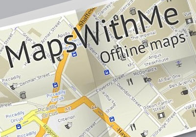
I'll tell you with my own example. Before going on a trip to Europe, I downloaded the GPS navigator MapsWithMe on my iPhone 4s. In 40 minutes I downloaded all the necessary countries that I was going to visit: Finland, Sweden, Estonia, Norway, Russia. I had never been anywhere other than Russia before, so I couldn’t even imagine what awaited me. But once I found myself in any of the listed countries, I easily found my way around without the help of a guide.
The program shows the nearest cafes and restaurants, game parks, shops, banks and ATMs. I also really liked the “Guide” function, which shows historical places and gives interesting and useful information about them. It is also convenient to set drop-off points, for example a ferry or an airport, and then get there without any problems. Maps are optimized, load quickly, scale, and their size varies from 10 to 150 MB.
However, there are also disadvantages to this navigation system; at the time of writing, this application does not provide route planning. However, I still recommend installing this application, especially if you like to sometimes go to other countries or cities without a car. For pedestrian navigation, this program is simply a bestseller.
Now let's look at the best car GPS navigator for iPhone?
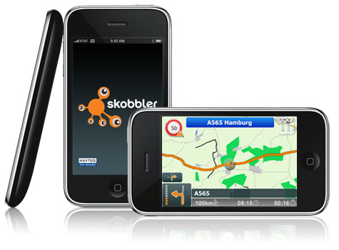
In the App Store it is called: “GPS navigation” from the company Skobbler, and in my opinion this is the best navigator I have ever tried. I was very pleased with the “Voice Navigation”, which reports everything, including the speed limit on a given section of the road, the nearest exit, turn, traffic police radars, etc. Maps works in both versions, if you do not have maps, then it is downloaded Online via the Internet, if you have downloaded maps, then the Internet is not required. Very high-quality route planning, leading along the shortest routes. In St. Petersburg, it easily identifies roundabouts, exits from the Ring Road, and back. He also sees all the changes and new roads. Very fast application, clear location determination, high-quality navigation and zooming. You can view both 2D and 3D maps.
Independent navigator for iPhone.
Also, for various occasions, I keep Yandex Navigator in my iPhone; it can plot a route taking into account traffic jams, in addition, it shows traffic jams and accidents on the roads. He has no other particularly important merits, but sometimes he helps out. In addition, Yandex navigator is a free application that anyone can install. During my work, I noticed a small drawback in this navigator: when driving a car along the highway, the beacon goes off the road and it seems as if you are driving on the side of the road. And so, overall, a good application.
Let's summarize. Which navigator should I install on my iPhone?
Personally, few people will like my opinion, but I suggest installing all three options: MapsWithMe, Yandex Navigator and GPS navigation from Skobbler. It's just a great option to keep a navigation system with you for different situations.
MapsWithMe-should be installed only if you like to travel and walk rather than drive.
Application "GPS navigation" from Skobbler It is worth installing only if you need voice guidance, as well as voice assistance about speed limits, obstacles, and traffic police radars. And also if you prefer to use GPS navigation in Offline mode without the Internet.
If everything said above does not bother you, and you just need route planning without any voice gadgets and amenities. That Yandex Navigator will be an excellent companion for you in all road matters.